


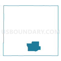
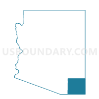
Precinct 24, Cochise County, Arizona
About
Outline

Summary
| Unique Area Identifier | 523684 |
| Name | Precinct 24 |
| County | Cochise County |
| State | Arizona |
| Area (square miles) | 230.71 |
| Land Area (square miles) | 230.30 |
| Water Area (square miles) | 0.41 |
| % of Land Area | 99.82 |
| % of Water Area | 0.18 |
| Latitude of the Internal Point | 31.53565080 |
| Longtitude of the Internal Point | -109.67507980 |
Maps

Graphs
Select a template below for downloading or customizing gragh for Precinct 24, Cochise County, Arizona


Neighbors
Neighoring Voting District (by Name) Neighboring Voting District on the Map
- Precinct 05, Cochise County, AZ
- Precinct 11, Cochise County, AZ
- Precinct 20, Cochise County, AZ
- Precinct 28, Cochise County, AZ
- Precinct 58, Cochise County, AZ
- Precinct 59, Cochise County, AZ
Top 10 Neighboring County Subdivision (by Population) Neighboring County Subdivision on the Map
- Bisbee CCD, Cochise County, AZ (29,838)
- Douglas CCD, Cochise County, AZ (19,772)
- Elfrida CCD, Cochise County, AZ (5,651)
Top 10 Neighboring Place (by Population) Neighboring Place on the Map
Top 10 Neighboring Elementary School District (by Population) Neighboring Elementary School District on the Map
- Elfrida Elementary District, AZ (1,121)
- McNeal Elementary District, AZ (507)
- Double Adobe Elementary District, AZ (482)
Top 10 Neighboring Secondary School District (by Population) Neighboring Secondary School District on the Map
Top 10 Neighboring Unified School District (by Population) Neighboring Unified School District on the Map
- School District Not Defined, AZ (69,809)
- Douglas Unified District, AZ (21,931)
- Tombstone Unified District, AZ (7,641)
- Bisbee Unified District, AZ (7,072)
Top 10 Neighboring State Legislative District Lower Chamber (by Population) Neighboring State Legislative District Lower Chamber on the Map
Top 10 Neighboring State Legislative District Upper Chamber (by Population) Neighboring State Legislative District Upper Chamber on the Map
Top 10 Neighboring 111th Congressional District (by Population) Neighboring 111th Congressional District on the Map
Top 10 Neighboring Census Tract (by Population) Neighboring Census Tract on the Map
- Census Tract 5, Cochise County, AZ (5,651)
- Census Tract 11, Cochise County, AZ (3,599)
- Census Tract 6, Cochise County, AZ (2,984)
- Census Tract 10, Cochise County, AZ (1,656)
Top 10 Neighboring 5-Digit ZIP Code Tabulation Area (by Population) Neighboring 5-Digit ZIP Code Tabulation Area on the Map
- 85607, AZ (18,925)
- 85603, AZ (7,155)
- 85608, AZ (2,305)
- 85638, AZ (1,973)
- 85610, AZ (1,333)
- 85617, AZ (1,277)